Accomplishments
White Sands Missile Range, New Mexico
White Sands Missile Range (WSMR) is the military’s largest all-overland test range in the Western Hemisphere and encompasses 2.2 million acres, which can be extended to 4 million acres (total) by including adjacent federal land holdings. WSMR houses the U.S. Army Research, Development, Test, and Evaluation (RDT&E) Command for weapons and space systems and components.Within WSMR are the San Andreas National Wildlife Refuge, White Sands National Monument (National Park Service), and Jordana Experimental Range (U.S. Department of Agriculture and U.S. Forest Service).
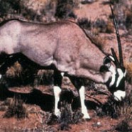
We successfully monitored and tracked Oryx (an introduced African antelope) via satellite on the WSMR to help military land managers comply with National Park Service and New Mexico Game and Fish requirements for managing this exotic species. Management of this exotic species has proven to be difficult for military land managers because of the Oryx’s preference for remote, rugged terrain. In addition, the Oryx population on WSMR could potentially affect adjacent natural systems off-base. Continuing work on Oryx work will employ the new SERDP developed GPS PTTs to track these animals to an accuracy of + 5 meters throughout the 2+ million acre WSMR installation.

Oryx
